
- Startseite >
- Flüsse >
- Wasserstand >
- Bayern >
- Mauthaus >
- Jahresgrafik

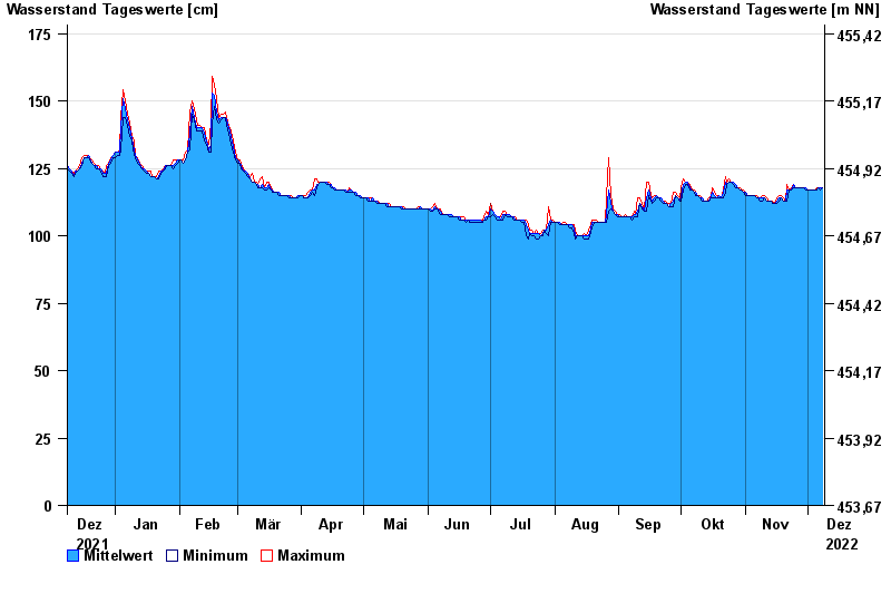
Jahresgrafik Mauthaus / Tschirner Ködel
Wasserstand vom 09.12.2021 bis zum 08.12.2022
- 14.02.1997 Wasserstand: 209 cm
- 03.01.2003 Wasserstand: 188 cm
- 27.01.2002 Wasserstand: 186 cm
- 13.02.2005 Wasserstand: 182 cm
- 24.12.1967 Wasserstand: 180 cm
| Datum | Mittelwert [cm] | Maximum [cm] | Minimum [cm] |
|---|---|---|---|
| 08.12.2022 | 118 | 118 | 118 |
| 07.12.2022 | 118 | 118 | 117 |
| 06.12.2022 | 118 | 118 | 118 |
| 05.12.2022 | 117 | 118 | 117 |
| 04.12.2022 | 117 | 117 | 117 |
| 03.12.2022 | 117 | 117 | 117 |
| 02.12.2022 | 117 | 117 | 117 |
© Bayerisches Landesamt für Umwelt 2024