
- Startseite >
- Flüsse >
- Wasserstand >
- Bayern >
- Kothmaißling >
- Jahresgrafik

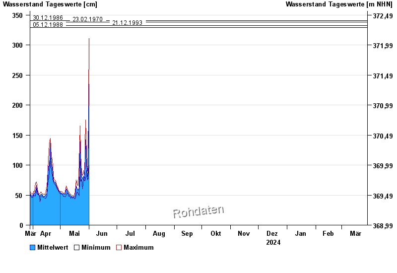
Jahresgrafik Kothmaißling / Chamb
Wasserstand vom 29.03.2024 bis zum 28.03.2025
Hinweis
Beeinflussung durch Buhneneinbau unterhalb vom Pegel
- 13.08.2002 Wasserstand: 364 cm
- 30.12.1986 Wasserstand: 341 cm
- 23.02.1970 Wasserstand: 338 cm
- 21.12.1993 Wasserstand: 332 cm
- 05.12.1988 Wasserstand: 329 cm
| Datum | Mittelwert [cm] | Maximum [cm] | Minimum [cm] |
|---|---|---|---|
| 09.05.2024 | 55 | 58 | 53 |
| 08.05.2024 | 57 | 60 | 54 |
| 07.05.2024 | 60 | 65 | 50 |
| 06.05.2024 | 51 | 55 | 47 |
| 05.05.2024 | 52 | 53 | 48 |
| 04.05.2024 | 52 | 54 | 48 |
| 03.05.2024 | 53 | 55 | 51 |
© Bayerisches Landesamt für Umwelt 2024