
- Startseite >
- Flüsse >
- Wasserstand >
- Bayern >
- Kothmaißling >
- Jahresgrafik

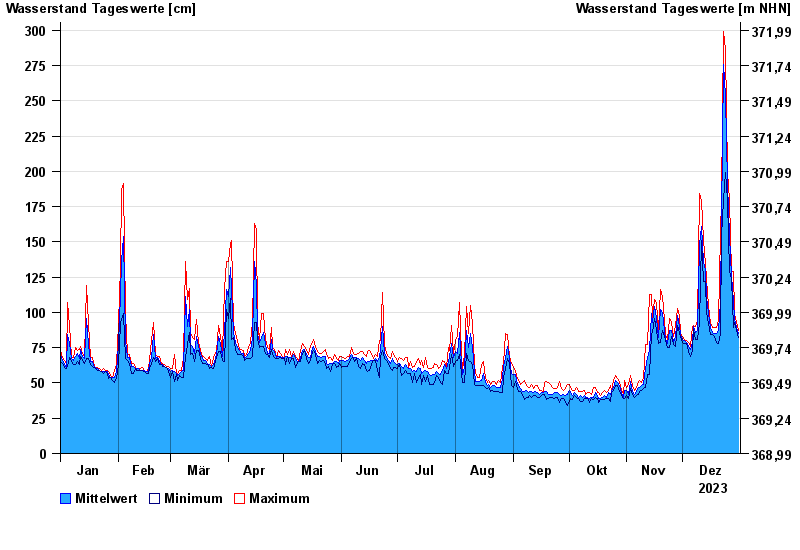
Jahresgrafik Kothmaißling / Chamb
Wasserstand vom 01.01.2023 bis zum 31.12.2023
Hinweis
Beeinflussung durch Buhneneinbau unterhalb vom Pegel
- 13.08.2002 Wasserstand: 364 cm
- 30.12.1986 Wasserstand: 341 cm
- 23.02.1970 Wasserstand: 338 cm
- 21.12.1993 Wasserstand: 332 cm
- 05.12.1988 Wasserstand: 329 cm
| Datum | Mittelwert [cm] | Maximum [cm] | Minimum [cm] |
|---|---|---|---|
| 31.12.2023 | 85 | 87 | 82 |
| 30.12.2023 | 89 | 93 | 87 |
| 29.12.2023 | 96 | 99 | 93 |
| 28.12.2023 | 108 | 129 | 89 |
| 27.12.2023 | 126 | 129 | 123 |
| 26.12.2023 | 154 | 179 | 129 |
| 25.12.2023 | 191 | 199 | 179 |
© Bayerisches Landesamt für Umwelt 2024