
- Startseite >
- Flüsse >
- Wasserstand >
- Bayern >
- Johannisthal >
- Jahresgrafik

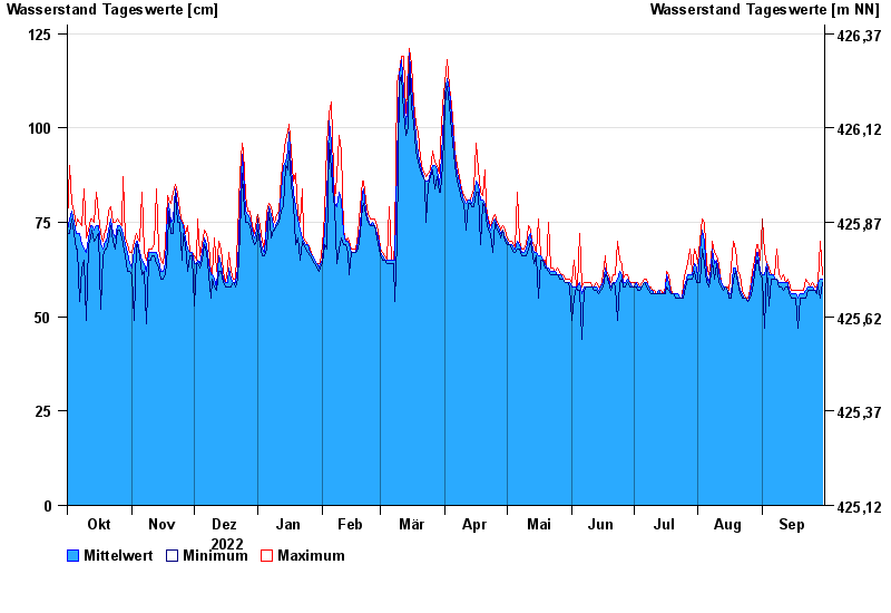
Jahresgrafik Johannisthal / Tirschenreuther Waldnaab
Wasserstand vom 01.10.2022 bis zum 30.09.2023
- 02.11.1998 Wasserstand: 221 cm
- 03.01.2003 Wasserstand: 220 cm
- 14.01.2011 Wasserstand: 214 cm
- 13.02.2005 Wasserstand: 203 cm
- 03.06.2013 Wasserstand: 202 cm
| Datum | Mittelwert [cm] | Maximum [cm] | Minimum [cm] |
|---|---|---|---|
| 30.09.2023 | 60 | 61 | 59 |
| 29.09.2023 | 60 | 70 | 55 |
| 28.09.2023 | 59 | 59 | 58 |
| 27.09.2023 | 57 | 58 | 56 |
| 26.09.2023 | 57 | 58 | 57 |
| 25.09.2023 | 58 | 59 | 57 |
| 24.09.2023 | 58 | 58 | 57 |
© Bayerisches Landesamt für Umwelt 2024