
- Start >
- Rivers >
- Waterlevel >
- Naab - Regen >
- Iglersreuth Speicherzufluss >
- Chart of total period

Chart of total period Iglersreuth Speicherzufluss / Tirschenreuther Waldnaab
Waterlevel from 01.11.1970 to 19.04.2024
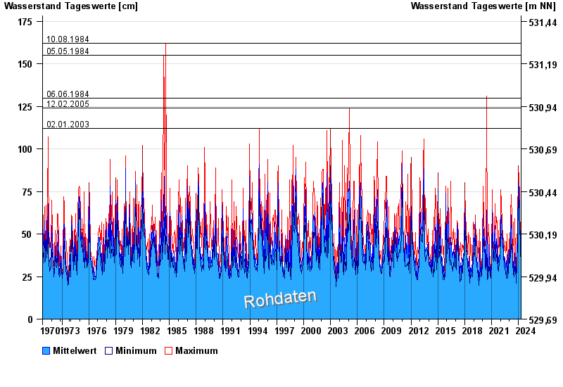
- 10.08.1984 Wasserstand: 162 cm
- 05.05.1984 Wasserstand: 155 cm
- 06.06.1984 Wasserstand: 130 cm
- 12.02.2005 Wasserstand: 124 cm
- 02.01.2003 Wasserstand: 112 cm
| Date | Mean value [cm] | Maximum [cm] | Minimum [cm] |
|---|---|---|---|
| 19.04.2024 | 34 | 39 | 32 |
| 18.04.2024 | 33 | 34 | 32 |
| 17.04.2024 | 36 | 39 | 34 |
| 16.04.2024 | 34 | 40 | 32 |
| 15.04.2024 | 32 | 33 | 31 |
| 14.04.2024 | 32 | 33 | 31 |
| 13.04.2024 | 32 | 34 | 31 |
© Bayerisches Landesamt für Umwelt 2024