
- Start >
- Rivers >
- Waterlevel >
- Unterer Main >
- Schöllkrippen >
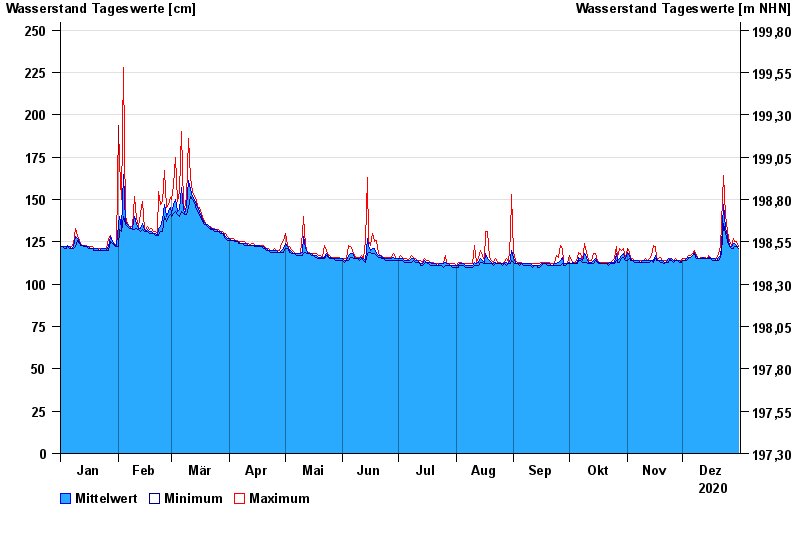
- Chart of year

Chart of year Schöllkrippen / Kahl
Waterlevel from 01.01.2020 to 31.12.2020
note
Neue Meldestufen 1 (190 cm) und Meldestufe 2 (220 cm)
- 28.05.2006 Wasserstand: 329 cm
- 04.05.2017 Wasserstand: 297 cm
- 28.01.2021 Wasserstand: 290 cm
- 02.01.2003 Wasserstand: 288 cm
- 09.02.2016 Wasserstand: 282 cm
| Date | Mean value [cm] | Maximum [cm] | Minimum [cm] |
|---|---|---|---|
| 31.12.2020 | 121 | 122 | 121 |
| 30.12.2020 | 123 | 125 | 122 |
| 29.12.2020 | 124 | 125 | 122 |
| 28.12.2020 | 124 | 127 | 121 |
| 27.12.2020 | 122 | 123 | 121 |
| 26.12.2020 | 123 | 125 | 122 |
| 25.12.2020 | 128 | 131 | 125 |
© Bayerisches Landesamt für Umwelt 2024