
- Start >
- Rivers >
- Waterlevel >
- Obere Donau >
- Manching (Ort) >
- Chart of year

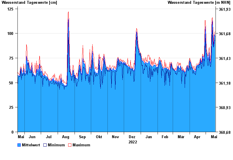
Chart of year Manching (Ort) / Paar
Waterlevel from 19.05.2022 to 18.05.2023
note
Seit Anfang August 2022 ist derzeit der Pegel durch eine Baumaßnahme im Gewässerbett beeinflusst. Die Abflussermittlung ist unsicher.
- 11.03.2006 Wasserstand: 285 cm
- 04.06.2013 Wasserstand: 284 cm
- 15.04.1994 Wasserstand: 279 cm
- 17.02.2006 Wasserstand: 228 cm
- 24.05.1999 Wasserstand: 226 cm
| Date | Mean value [cm] | Maximum [cm] | Minimum [cm] |
|---|---|---|---|
| 18.05.2023 | 97 | 102 | 93 |
| 17.05.2023 | 99 | 101 | 93 |
| 16.05.2023 | 91 | 94 | 88 |
| 15.05.2023 | 87 | 88 | 86 |
| 14.05.2023 | 93 | 103 | 88 |
| 13.05.2023 | 113 | 116 | 103 |
| 12.05.2023 | 108 | 115 | 94 |
© Bayerisches Landesamt für Umwelt 2024