
- Start >
- Rivers >
- Waterlevel >
- Isar >
- Dürrach >
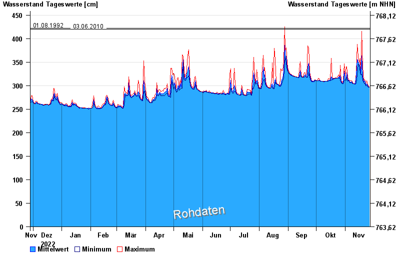
- Chart of year

Chart of year Dürrach / Dürrach
Waterlevel from 28.11.2022 to 27.11.2023
Beeinflussung
Wasserstand durch starke Aufkiesung beeinflusst, der Abfluss ist ungültig
- 01.08.1977 Wasserstand: 599 cm
- 23.08.2005 Wasserstand: 487 cm
- 22.05.1999 Wasserstand: 459 cm
- 01.08.1992 Wasserstand: 422 cm
- 03.06.2010 Wasserstand: 420 cm
| Date | Mean value [cm] | Maximum [cm] | Minimum [cm] |
|---|---|---|---|
| 27.11.2023 | 297 | 298 | 297 |
| 26.11.2023 | 299 | 300 | 297 |
| 25.11.2023 | 302 | 306 | 300 |
| 24.11.2023 | 304 | 310 | 300 |
| 23.11.2023 | 302 | 305 | 300 |
| 22.11.2023 | 310 | 313 | 305 |
| 21.11.2023 | 308 | 312 | 306 |
© Bayerisches Landesamt für Umwelt 2024