
- Start >
- Rivers >
- Waterlevel >
- Isar >
- Dürrach >
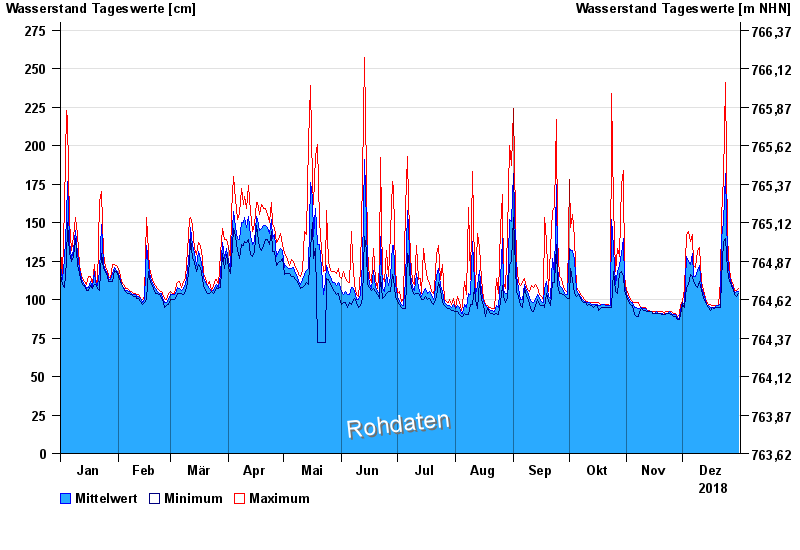
- Chart of year

Chart of year Dürrach / Dürrach
Waterlevel from 01.01.2018 to 31.12.2018
Beeinflussung
Wasserstand durch starke Aufkiesung beeinflusst, der Abfluss ist ungültig
- 01.08.1977 Wasserstand: 599 cm
- 23.08.2005 Wasserstand: 487 cm
- 22.05.1999 Wasserstand: 459 cm
- 01.08.1992 Wasserstand: 422 cm
- 03.06.2010 Wasserstand: 420 cm
| Date | Mean value [cm] | Maximum [cm] | Minimum [cm] |
|---|---|---|---|
| 31.12.2018 | 105 | 107 | 104 |
| 30.12.2018 | 105 | 106 | 102 |
| 29.12.2018 | 104 | 106 | 103 |
| 28.12.2018 | 107 | 109 | 106 |
| 27.12.2018 | 110 | 112 | 109 |
| 26.12.2018 | 115 | 119 | 112 |
| 25.12.2018 | 128 | 140 | 119 |
© Bayerisches Landesamt für Umwelt 2024