
- Start >
- Rivers >
- Waterlevel >
- Inn >
- Berchtesgaden-Klärwerk >
- Chart of year

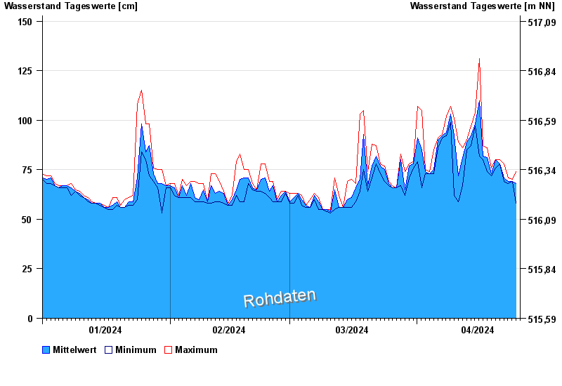
Chart of year Berchtesgaden-Klärwerk / Berchtesgadener Ache
Waterlevel from 01.01.2024 to 25.04.2024
- 17.07.2021 Wasserstand: 383 cm
- 02.06.2013 Wasserstand: 312 cm
- 12.08.2002 Wasserstand: 295 cm
- 26.06.1995 Wasserstand: 286 cm
- 11.07.2005 Wasserstand: 277 cm
| Date | Mean value [cm] | Maximum [cm] | Minimum [cm] |
|---|---|---|---|
| 25.04.2024 | 68 | 74 | 58 |
| 24.04.2024 | 69 | 70 | 69 |
| 23.04.2024 | 69 | 71 | 68 |
| 22.04.2024 | 71 | 78 | 69 |
| 21.04.2024 | 78 | 80 | 78 |
| 20.04.2024 | 80 | 80 | 76 |
| 19.04.2024 | 73 | 76 | 72 |
© Bayerisches Landesamt für Umwelt 2024