
- Start >
- Rivers >
- Waterlevel >
- Iller - Lech - Bodensee >
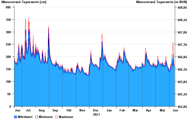
- Neu Ulm, Bad Held >
- Chart of year

Chart of year Neu Ulm, Bad Held / Donau
Waterlevel from 14.06.2021 to 13.06.2022
ACHTUNG!
Pegel durch außerordentlichen Kraftwerksbetrieb beeinflusst.
- 23.05.1999 Wasserstand: 571 cm
- 24.08.2005 Wasserstand: 543 cm
- 03.06.2013 Wasserstand: 502 cm
- 16.02.1990 Wasserstand: 471 cm
- 13.08.2002 Wasserstand: 469 cm
| Date | Mean value [cm] | Maximum [cm] | Minimum [cm] |
|---|---|---|---|
| 13.06.2022 | 163 | 167 | 160 |
| 12.06.2022 | 165 | 170 | 161 |
| 11.06.2022 | 174 | 190 | 168 |
| 10.06.2022 | 210 | 251 | 189 |
| 09.06.2022 | 193 | 258 | 167 |
| 08.06.2022 | 192 | 206 | 174 |
| 07.06.2022 | 173 | 208 | 154 |
© Bayerisches Landesamt für Umwelt 2024