
- Start >
- Rivers >
- Waterlevel >
- Iller - Lech - Bodensee >
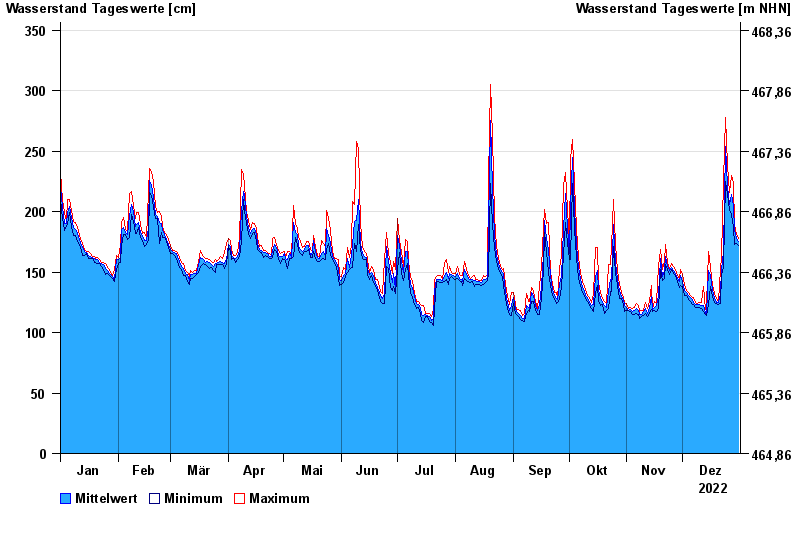
- Neu Ulm, Bad Held >
- Chart of year

Chart of year Neu Ulm, Bad Held / Donau
Waterlevel from 01.01.2022 to 31.12.2022
ACHTUNG!
Pegel durch außerordentlichen Kraftwerksbetrieb beeinflusst.
- 23.05.1999 Wasserstand: 571 cm
- 24.08.2005 Wasserstand: 543 cm
- 03.06.2013 Wasserstand: 502 cm
- 16.02.1990 Wasserstand: 471 cm
- 13.08.2002 Wasserstand: 469 cm
| Date | Mean value [cm] | Maximum [cm] | Minimum [cm] |
|---|---|---|---|
| 31.12.2022 | 175 | 178 | 172 |
| 30.12.2022 | 178 | 181 | 174 |
| 29.12.2022 | 184 | 189 | 173 |
| 28.12.2022 | 204 | 223 | 187 |
| 27.12.2022 | 214 | 230 | 198 |
| 26.12.2022 | 206 | 216 | 201 |
| 25.12.2022 | 221 | 238 | 214 |
© Bayerisches Landesamt für Umwelt 2024