
- Start >
- Rivers >
- Waterlevel >
- Oberer Main - Elbe >
- Schönstädt >
- Chart of year

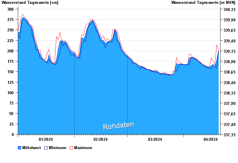
Chart of year Schönstädt / Itz
Waterlevel from 01.01.2024 to 20.04.2024
note
Abfluss ohne Ausleitung über den ehemaligenTriebwerkskanal
- 02.01.1987 Wasserstand: 332 cm
- 29.01.2002 Wasserstand: 323 cm
- 04.03.1999 Wasserstand: 314 cm
- 23.10.1986 Wasserstand: 309 cm
- 17.09.1998 Wasserstand: 302 cm
| Date | Mean value [cm] | Maximum [cm] | Minimum [cm] |
|---|---|---|---|
| 20.04.2024 | 200 | 202 | 199 |
| 19.04.2024 | 177 | 215 | 158 |
| 18.04.2024 | 163 | 166 | 161 |
| 17.04.2024 | 167 | 174 | 164 |
| 16.04.2024 | 165 | 184 | 158 |
| 15.04.2024 | 160 | 161 | 158 |
| 14.04.2024 | 162 | 162 | 160 |
© Bayerisches Landesamt für Umwelt 2024