
- Start >
- Rivers >
- Waterlevel >
- Oberer Main - Elbe >
- Pottenstein >
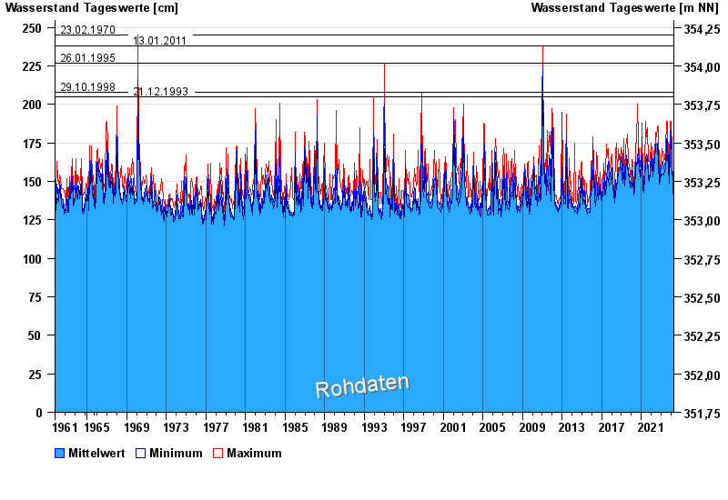
- Chart of total period

Chart of total period Pottenstein / Püttlach
Waterlevel from 29.09.1961 to 18.04.2024
note
Abfluss durch starke Verkrautung behindert; Abflusswerte unsicher
- 23.02.1970 Wasserstand: 245 cm
- 13.01.2011 Wasserstand: 238 cm
- 26.01.1995 Wasserstand: 227 cm
- 29.10.1998 Wasserstand: 208 cm
- 21.12.1993 Wasserstand: 205 cm
| Date | Mean value [cm] | Maximum [cm] | Minimum [cm] |
|---|---|---|---|
| 18.04.2024 | 143 | 144 | 143 |
| 17.04.2024 | 144 | 145 | 143 |
| 16.04.2024 | 143 | 150 | 140 |
| 15.04.2024 | 141 | 142 | 140 |
| 14.04.2024 | 141 | 141 | 140 |
| 13.04.2024 | 141 | 141 | 140 |
| 12.04.2024 | 140 | 141 | 140 |
© Bayerisches Landesamt für Umwelt 2024