
- Start >
- Groundwater >
- Waterlevel of upper layer >
- Obere Donau >
- Neu-Ulm, Ludwigsfeld, Auffahrt B30 - BAB >
- Chart of total period

Chart of total period Neu-Ulm, Ludwigsfeld, Auffahrt B30 - BAB
Groundwater levels of the total period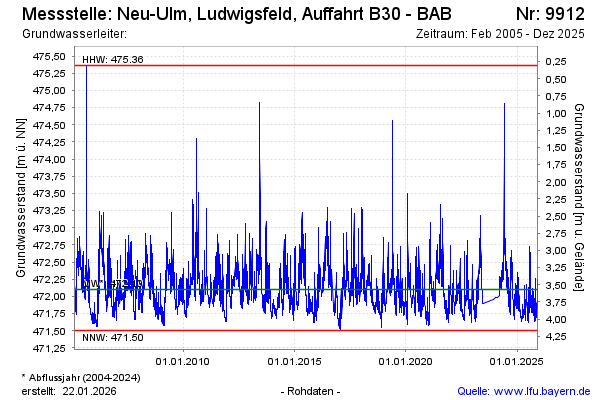
Groundwater level [m above sealevel]: 471.83
Distance to surface [m]: 3.84
Last value from 18.09.2025 09:53
Ground level [m above sealevel]: 475.67
| Date | Groundwater level [m above sealevel] |
|---|---|
| 18.09.2025 | 471.84 |
| 17.09.2025 | 471.86 |
| 16.09.2025 | 471.83 |
| 15.09.2025 | 471.84 |
| 14.09.2025 | 471.77 |
| 13.09.2025 | 471.77 |
| 12.09.2025 | 471.80 |
| 11.09.2025 | 471.84 |
© Bayerisches Landesamt für Umwelt 2025