
- Start >
- Groundwater >
- Waterlevel of upper layer >
- Obere Donau >
- ALLMANNSHOFEN 59 >
- Chart of total period

Chart of total period ALLMANNSHOFEN 59
Groundwater levels of the total period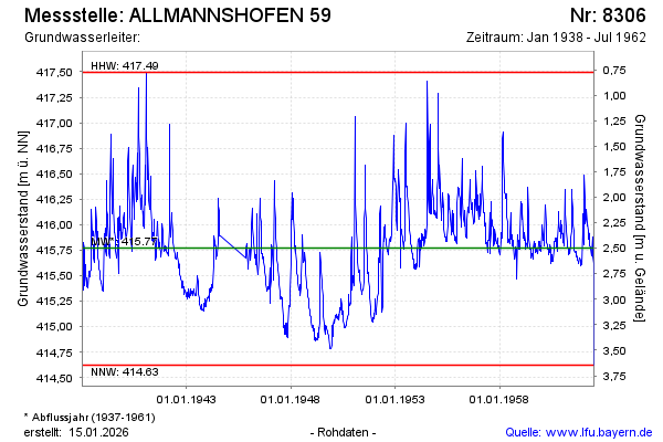
Groundwater level [m above sealevel]: 415.58
Distance to surface [m]: 2.69
Last value from 09.07.1962 12:00
Ground level [m above sealevel]: 418.27
| Date | Groundwater level [m above sealevel] |
|---|---|
| 02.07.1962 | 414.63 |
| 25.06.1962 | 415.62 |
| 18.06.1962 | 415.68 |
| 12.06.1962 | 415.76 |
| 04.06.1962 | 415.89 |
| 28.05.1962 | 415.73 |
| 21.05.1962 | 415.71 |
| 14.05.1962 | 415.69 |
© Bayerisches Landesamt für Umwelt 2024