
- Start >
- Groundwater >
- Waterlevel of upper layer >
- Isar >
- LEITERSHOFEN 89 >
- Chart of total period

Chart of total period LEITERSHOFEN 89
Groundwater levels of the total period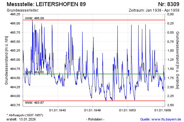
Groundwater level [m above sealevel]: 484.45
Distance to surface [m]: 1.80
Last value from 28.04.1958 12:00
Ground level [m above sealevel]: 486.25
| Date | Groundwater level [m above sealevel] |
|---|---|
| 21.04.1958 | 484.53 |
| 14.04.1958 | 484.49 |
| 08.04.1958 | 484.44 |
| 31.03.1958 | 484.49 |
| 24.03.1958 | 484.55 |
| 17.03.1958 | 484.53 |
| 10.03.1958 | 484.57 |
| 03.03.1958 | 484.67 |
© Bayerisches Landesamt für Umwelt 2024