
- Start >
- Groundwater >
- Waterlevel of upper layer >
- Inn >
- NEUORTHOFEN 260 >
- Chart of total period

Chart of total period NEUORTHOFEN 260
Groundwater levels of the total period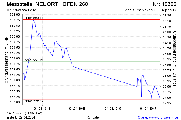
note
Die Messstelle wurde 1947 zurück gebaut.
Groundwater level [m above sealevel]: 557.13
Distance to surface [m]: 27.08
Last value from 08.09.1947 12:00
Ground level [m above sealevel]: 584.21
| Date | Groundwater level [m above sealevel] |
|---|---|
| 01.09.1947 | 557.17 |
| 25.08.1947 | 557.21 |
| 18.08.1947 | 557.25 |
| 11.08.1947 | 557.29 |
| 04.08.1947 | 557.32 |
| 28.07.1947 | 557.36 |
| 21.07.1947 | 557.41 |
| 14.07.1947 | 557.46 |
© Bayerisches Landesamt für Umwelt 2024