
- Start >
- Groundwater >
- Waterlevel of upper layer >
- Bayern >
- BETZENSTEIN,T.BR.TB 1 >
- Chart of total period

Chart of total period BETZENSTEIN,T.BR.TB 1
Groundwater levels of the total period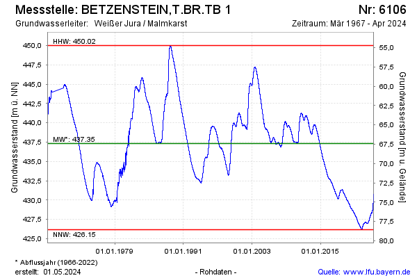
Groundwater level [m above sealevel]: 430.55
Distance to surface [m]: 74.18
Last value from 24.04.2024 02:00
Ground level [m above sealevel]: 504.73
| Date | Groundwater level [m above sealevel] |
|---|---|
| 23.04.2024 | 430.52 |
| 22.04.2024 | 430.49 |
| 21.04.2024 | 430.47 |
| 20.04.2024 | 430.44 |
| 19.04.2024 | 430.42 |
| 18.04.2024 | 430.38 |
| 17.04.2024 | 430.37 |
| 16.04.2024 | 430.35 |
© Bayerisches Landesamt für Umwelt 2024