
- Start >
- Groundwater >
- Flow of springs >
- Unterer Main >
- Waldbrunnen 2/3 >
- Master data

Master data Waldbrunnen 2/3
Site number: 22502
Measuring point system: Grundnetz
Community: --
District: Bad Kissingen
Measurement data provided by:  Wasserwirtschaftsamt Bad Kissingen
Aquifer: Oberer Buntsandstein
Ground level: 560.00 m above sealevel
Easting: 564613 (ETRS89 / UTM Zone 32N)
Northing: 5572149
Observation period: 21.05.1951 to 18.04.2024
Maximum flow: 15.02 l/s
Mean flow: 4.00 l/s
Minimum flow: 0.95 l/s
Picture of the measurement site
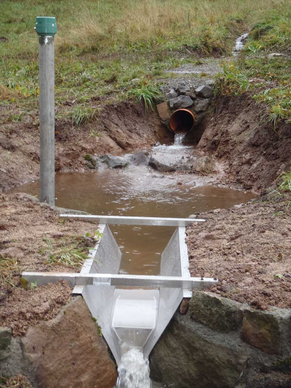
Location of the station Waldbrunnen 2/3
| Measurement site | Category |
|---|---|
 Gräfendorf Gräfendorf | Rivers: Runoff, Waterlevel, Water temperature, Water temperature |
| Unterweißenbrunn | Rivers: Runoff, Waterlevel |
| Schweinhof | Rivers: Runoff, Waterlevel |
| Oberthulba | Rivers: Runoff, Waterlevel |
| Bad Brückenau | Rivers: Runoff, Waterlevel, Water temperature, Water temperature |
| Wolfsmünster | Rivers: Runoff, Waterlevel, Water temperature, Water temperature, Suspended sediment |
| Schlimpfhof | Rivers: Runoff, Waterlevel |
| Bad Kissingen Golfplatz | Rivers: Runoff, Waterlevel |
| Waldberg | Rivers: Runoff, Waterlevel |
| Gemünden Lachsfangsteg | Rivers: Runoff, Waterlevel |
| Bad Kissingen Prinzreg.-bau | Rivers: Waterlevel, Water temperature, Water temperature |
| Bad Brückenau Staatsbad | Rivers: Waterlevel |
| Gemünden oh. Sinnmündung | Rivers: Chemistry, Biology |
| Gemünden Wegbrücke | Rivers: Chemistry, Biology |
| km 2,75 oh Wehr | Rivers: Chemistry, Biology |
| 01-KG - Hammelburg | Rivers: Chemistry |
| Bad Brückenau, Pegel Chemie | Rivers: Chemistry |
| 12-KG - Bad Kissingen | Rivers: Chemistry |
| Schweinhof, Pegel | Rivers: Chemistry |
| Bad Kissingen, Luitp.steg | Rivers: Chemistry, Biology |
| Zeitlofs | Rivers: Chemistry |
| Hausen | Rivers: Chemistry, Biology |
| Thulba, uh ehem. KA | Rivers: Chemistry, Biology |
| Oberbach, oh. KA | Rivers: Chemistry, Biology |
| Bad Brückenau, Pegel | Rivers: Chemistry, Biology |
| Roth, oh | Rivers: Chemistry, Biology |
| Nüdlingen, uh. letzter RÜ KA | Rivers: Chemistry, Biology |
| Heiligkreuz | Rivers: Chemistry |
| 06-WB - Aschach | Rivers: Chemistry |
| Borstmühle, oh | Rivers: Biology |
| Morlesau, oh Br. | Rivers: Biology |
| Morlesau uh, Flkm 14,5 | Rivers: Biology |
| UNTERWEISSENBRUNN K | Groundwater: Deep groundwater layer |
| Reichthalshof MU4 | Groundwater: Upper groundwater layer |
| Kothen S5 | Groundwater: Upper groundwater layer |
| Stetten S1 | Groundwater: Upper groundwater layer |
| Windheim S7 | Groundwater: Deep groundwater layer |
| Sulzthalquelle | Groundwater: Flow of well, Temperature of springs |
| Seeleinsquelle-Heiligkreuz | Groundwater: Flow of well, Temperature of springs |
| Waldbrunnen 2/3 | Groundwater: Flow of well, Temperature of springs |
| Unterelsbach S3 | Groundwater: Upper groundwater layer |
| RIENECK 164 | Groundwater: Upper groundwater layer |
| Spielkasino P6 | Groundwater: Upper groundwater layer |
| Fuchsstadt Mu3 | Groundwater: Deep groundwater layer |
| Bischofsheim S2 | Groundwater: Deep groundwater layer |
| Gefäll S4 | Groundwater: Deep groundwater layer |
| OBERTHULBA B 212 | Groundwater: Upper groundwater layer |
| Schönderling S6 | Groundwater: Upper groundwater layer |
| Heiligkreuz S8 | Groundwater: Upper groundwater layer |
| PFAFFENHAUSEN 82A | Groundwater: Upper groundwater layer |
| WEGFURT H | Groundwater: Upper groundwater layer |
| Kurgarten Rampe KB1 | Groundwater: Upper groundwater layer |
| Kurgarten Wandelhalle KB12 | Groundwater: Upper groundwater layer |
| Kurhausbad P110 | Groundwater: Upper groundwater layer |
| HAMMELBG SANDECK 189 | Groundwater: Upper groundwater layer |
| LANGENDORF 223 | Groundwater: Upper groundwater layer |
| WEGFURT N | Groundwater: Upper groundwater layer |
| Obbach Ku1 | Groundwater: Upper groundwater layer |
| 4110592400004 | Groundwater: Chemistry |
| 4110592400009 | Groundwater: Chemistry |
| 4110552600003 | Groundwater: Chemistry |
| 4110562500005 | Groundwater: Chemistry |
| 4110582500016 | Groundwater: Chemistry |
| 4110582600029 | Groundwater: Chemistry |
| 4120572400022 | Groundwater: Chemistry |
| 4120572500002 | Groundwater: Chemistry |
| 4120582600038 | Groundwater: Chemistry |
| 4110562400002 | Groundwater: Chemistry |
| 1131582600067 | Groundwater: Chemistry |
| 1132572400082 | Groundwater: Chemistry |
| 4120552600036 | Groundwater: Chemistry |
| 1132572500091 | Groundwater: Chemistry |
| 1131592600055 | Groundwater: Chemistry |
| 1132572600084 | Groundwater: Chemistry |
| 4120582500022 | Groundwater: Chemistry |
| 4120552600015 | Groundwater: Chemistry |
| Hammelburg | Meteorology: Precipitation, Snow |
| Gräfendorf | Meteorology: Precipitation, Snow |
| Fladungen-Leubach | Meteorology: Precipitation, Snow, Air temperatur, Air moisture |
| Brückenau Staatsbad | Meteorology: Precipitation, Snow, Wind, Air temperatur, Air moisture, Air pressure, Global radiation |
| Hammelburg-Seeshof | Meteorology: Precipitation, Wind, Air temperatur, Air moisture, Global radiation |
| Bischofsheim/Rhön-Türmchen | Meteorology: Snow |
© Bayerisches Landesamt für Umwelt 2024