
- Start >
- Groundwater >
- Waterlevel of deep layer >
- Iller - Lech - Bodensee >
- THANNHAUSEN C,TB 888 >
- Chart of total period

Chart of total period THANNHAUSEN C,TB 888
Groundwater levels of the total period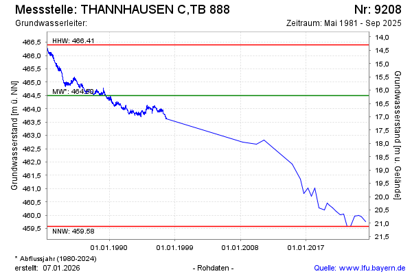
Groundwater level [m above sealevel]: 459.97
Distance to surface [m]: 20.73
Last value from 05.09.2023 08:25
Ground level [m above sealevel]: 480.70
| Date | Groundwater level [m above sealevel] |
|---|---|
| 23.02.2023 | 459.59 |
| 02.09.2022 | 459.58 |
| 17.02.2022 | 460.05 |
| 07.09.2021 | 460.01 |
| 02.03.2021 | 460.14 |
| 02.09.2020 | 460.27 |
| 12.03.2020 | 460.37 |
| 27.11.2019 | 460.45 |
© Bayerisches Landesamt für Umwelt 2024