
- Startseite >
- Grundwasser >
- Quellschüttung >
- Bayern >
- Hummelquelle Geiselwind >
- Gesamtzeitraum

Gesamtzeitraum Hummelquelle Geiselwind
Quellschüttungen im Gesamtzeitraum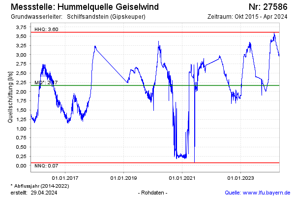
Schüttung [l/s]: 3,06
Letzter Messwert vom 16.04.2024 00:00
Geländehöhe [m ü. NN]: 340,00
| Datum | Quellschüttung [l/s] |
|---|---|
| 15.04.2024 | 3,07 |
| 14.04.2024 | 3,06 |
| 13.04.2024 | 3,06 |
| 12.04.2024 | 3,06 |
| 11.04.2024 | 3,06 |
| 10.04.2024 | 3,07 |
| 09.04.2024 | 3,11 |
| 08.04.2024 | 3,14 |
 weitere Messwerte weitere Messwerte | |

© Bayerisches Landesamt für Umwelt 2024