
- Startseite >
- Grundwasser >
- Wasserstand oberes Stockwerk >
- Untere Donau >
- Mallersdorf Q6 >
- Gesamtzeitraum

Gesamtzeitraum Mallersdorf Q6
Grundwasserstände im Gesamtzeitraum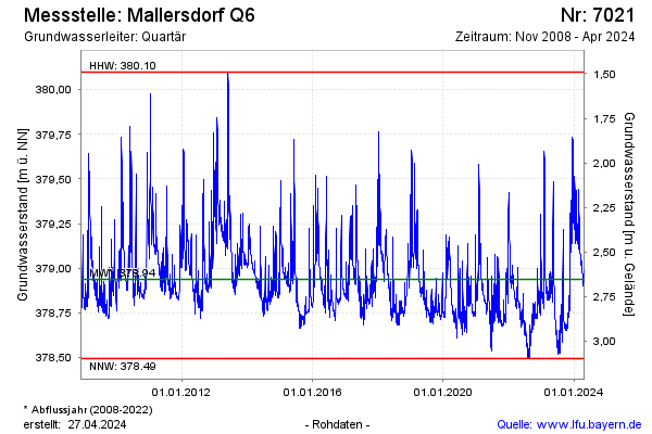
Hinweis
GW Messstelle im Grundnetz
Grundwasserstand [m ü. NN]: 378,95
Flurabstand [m u. Gelände]: 2,64
Letzter Messwert vom 18.04.2024 08:00
Geländehöhe [m ü. NN]: 381,59
| Datum | Grundwasserstand [m ü. NN] |
|---|---|
| 18.04.2024 | 378,94 |
| 17.04.2024 | 378,94 |
| 16.04.2024 | 378,93 |
| 15.04.2024 | 378,92 |
| 14.04.2024 | 378,92 |
| 13.04.2024 | 378,92 |
| 12.04.2024 | 378,92 |
| 11.04.2024 | 378,90 |
© Bayerisches Landesamt für Umwelt 2024