
- Startseite >
- Flüsse >
- Wasserstand >
- Naab - Regen >
- Johannisthal >
- Jahresgrafik

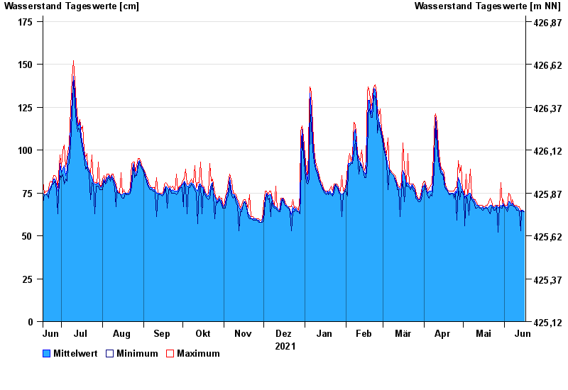
Jahresgrafik Johannisthal / Tirschenreuther Waldnaab
Wasserstand vom 17.06.2021 bis zum 16.06.2022
- 02.11.1998 Wasserstand: 221 cm
- 03.01.2003 Wasserstand: 220 cm
- 14.01.2011 Wasserstand: 214 cm
- 13.02.2005 Wasserstand: 203 cm
- 03.06.2013 Wasserstand: 202 cm
| Datum | Mittelwert [cm] | Maximum [cm] | Minimum [cm] |
|---|---|---|---|
| 16.06.2022 | 64 | 64 | 64 |
| 15.06.2022 | 65 | 65 | 64 |
| 14.06.2022 | 65 | 65 | 65 |
| 13.06.2022 | 64 | 65 | 53 |
| 12.06.2022 | 65 | 67 | 64 |
| 11.06.2022 | 66 | 67 | 65 |
| 10.06.2022 | 67 | 68 | 65 |
© Bayerisches Landesamt für Umwelt 2024