
- Startseite >
- Flüsse >
- Wasserstand >
- Unterer Main >
- Bad Königshofen im Grabfeld >
- Monatsgrafik

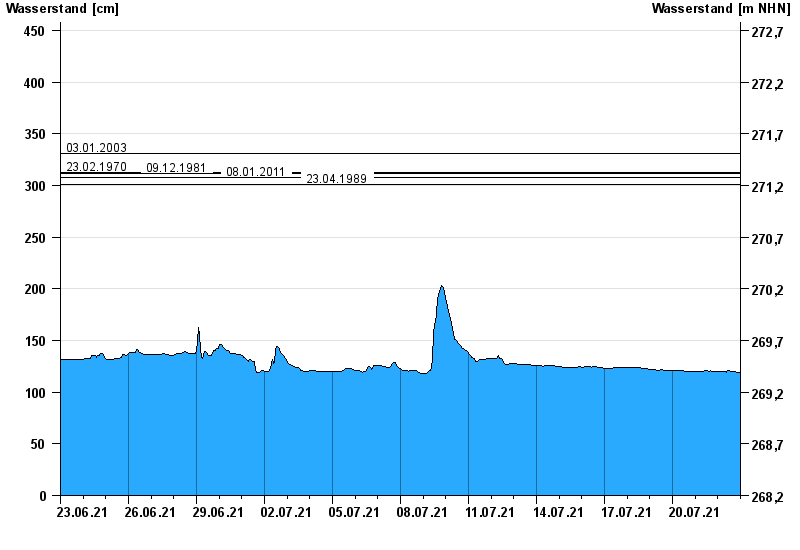
Monatsgrafik Bad Königshofen im Grabfeld / Fränkische Saale
Wasserstand vom 23.06.2021 bis zum 22.07.2021
Hinweis
Biberaktivität: Werte können durch Aufstau beeinflusst sein
- 03.01.2003 Wasserstand: 331 cm
- 23.02.1970 Wasserstand: 313 cm
- 09.12.1981 Wasserstand: 312 cm
- 08.01.2011 Wasserstand: 308 cm
- 23.04.1989 Wasserstand: 301 cm
| Datum | Wasserstand [cm] |
|---|---|
| 23.07.2021 00:45 | 119 |
| 23.07.2021 00:30 | 119 |
| 23.07.2021 00:15 | 119 |
| 23.07.2021 00:00 | 119 |
| 22.07.2021 23:45 | 119 |
| 22.07.2021 23:30 | 119 |
| 22.07.2021 23:15 | 119 |
© Bayerisches Landesamt für Umwelt 2024