
- Startseite >
- Flüsse >
- Wasserstand >
- Unterer Main >
- Bad Königshofen im Grabfeld >
- Jahresgrafik

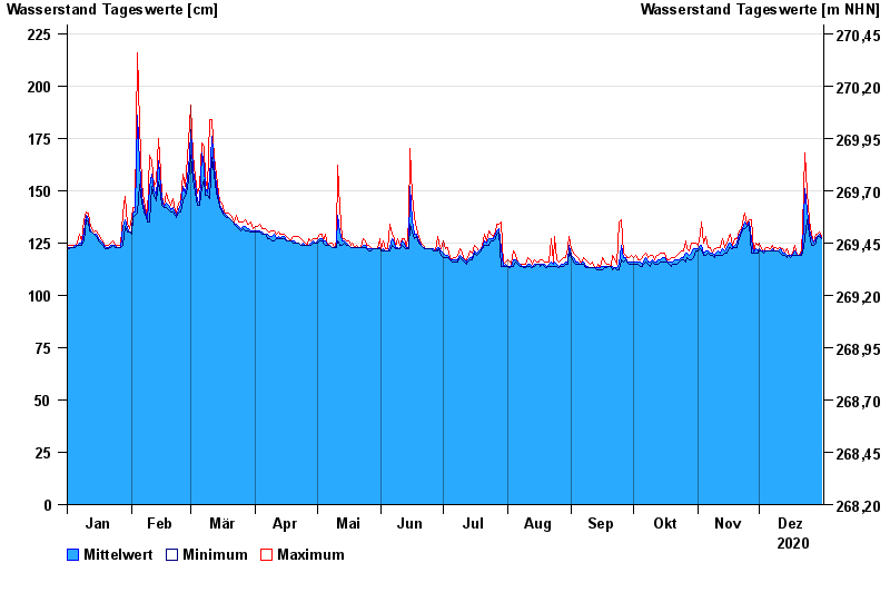
Jahresgrafik Bad Königshofen im Grabfeld / Fränkische Saale
Wasserstand vom 01.01.2020 bis zum 31.12.2020
Hinweis
Biberaktivität: Werte können durch Aufstau beeinflusst sein
- 03.01.2003 Wasserstand: 331 cm
- 23.02.1970 Wasserstand: 313 cm
- 09.12.1981 Wasserstand: 312 cm
- 08.01.2011 Wasserstand: 308 cm
- 23.04.1989 Wasserstand: 301 cm
| Datum | Mittelwert [cm] | Maximum [cm] | Minimum [cm] |
|---|---|---|---|
| 31.12.2020 | 127 | 128 | 127 |
| 30.12.2020 | 129 | 130 | 128 |
| 29.12.2020 | 128 | 129 | 128 |
| 28.12.2020 | 127 | 129 | 125 |
| 27.12.2020 | 125 | 125 | 124 |
| 26.12.2020 | 127 | 129 | 124 |
| 25.12.2020 | 132 | 136 | 129 |
© Bayerisches Landesamt für Umwelt 2024