
- Startseite >
- Flüsse >
- Wasserstand >
- Iller - Lech - Bodensee >
- Türkheim >
- Jahresgrafik

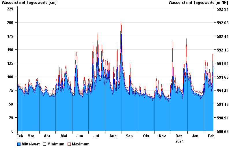
Jahresgrafik Türkheim / Wertach
Wasserstand vom 19.02.2021 bis zum 18.02.2022
Hinweis
Beeinflussung durch Kraftwerksbetrieb
- 23.08.2005 Wasserstand: 309 cm
- 12.08.2002 Wasserstand: 291 cm
- 02.06.2013 Wasserstand: 277 cm
- 06.08.2010 Wasserstand: 252 cm
- 03.06.2010 Wasserstand: 243 cm
| Datum | Mittelwert [cm] | Maximum [cm] | Minimum [cm] |
|---|---|---|---|
| 18.02.2022 | 120 | 142 | 107 |
| 17.02.2022 | 106 | 142 | 78 |
| 16.02.2022 | 82 | 88 | 77 |
| 15.02.2022 | 79 | 83 | 71 |
| 14.02.2022 | 85 | 91 | 79 |
| 13.02.2022 | 89 | 94 | 85 |
| 12.02.2022 | 97 | 112 | 90 |
© Bayerisches Landesamt für Umwelt 2024