
- Startseite >
- Flüsse >
- Wasserstand >
- Oberer Main - Elbe >
- Pettstadt >
- Jahresgrafik

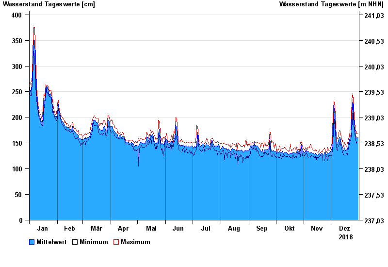
Jahresgrafik Pettstadt / Regnitz
Wasserstand vom 01.01.2018 bis zum 31.12.2018
- 09.01.2011 Wasserstand: 593 cm
- 02.06.2013 Wasserstand: 505 cm
- 10.12.2010 Wasserstand: 444 cm
- 11.03.2006 Wasserstand: 417 cm
- 16.01.2011 Wasserstand: 404 cm
| Datum | Mittelwert [cm] | Maximum [cm] | Minimum [cm] |
|---|---|---|---|
| 31.12.2018 | 161 | 168 | 152 |
| 30.12.2018 | 160 | 168 | 152 |
| 29.12.2018 | 160 | 168 | 149 |
| 28.12.2018 | 166 | 179 | 158 |
| 27.12.2018 | 178 | 187 | 167 |
| 26.12.2018 | 200 | 219 | 185 |
| 25.12.2018 | 236 | 247 | 219 |
© Bayerisches Landesamt für Umwelt 2024