
- Startseite >
- Flüsse >
- Wasserstand >
- Oberer Main - Elbe >
- Grafenwöhr >
- Jahresgrafik

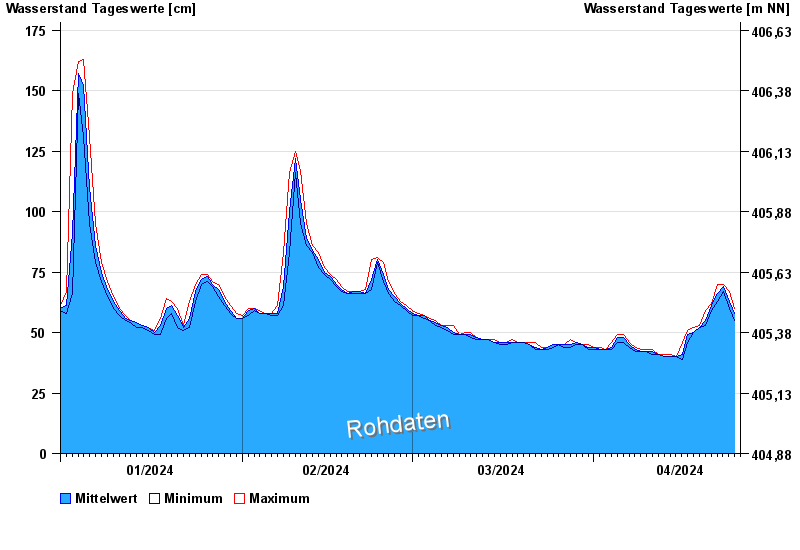
Jahresgrafik Grafenwöhr / Creußen
Wasserstand vom 01.01.2024 bis zum 25.04.2024
- 23.02.1970 Wasserstand: 237 cm
- 26.01.1995 Wasserstand: 232 cm
- 14.01.2011 Wasserstand: 227 cm
- 06.06.1984 Wasserstand: 225 cm
- 03.01.2003 Wasserstand: 224 cm
| Datum | Mittelwert [cm] | Maximum [cm] | Minimum [cm] |
|---|---|---|---|
| 25.04.2024 | 60 | 60 | 60 |
| 24.04.2024 | 63 | 67 | 60 |
| 23.04.2024 | 69 | 70 | 67 |
| 22.04.2024 | 66 | 70 | 63 |
| 21.04.2024 | 61 | 62 | 59 |
| 20.04.2024 | 55 | 59 | 53 |
| 19.04.2024 | 52 | 53 | 52 |
© Bayerisches Landesamt für Umwelt 2024