
- Startseite >
- Flüsse >
- Wasserstand >
- Bayern >
- Viechtach Reibenmühle >
- Jahresgrafik

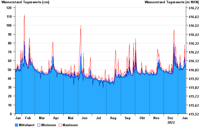
Jahresgrafik Viechtach Reibenmühle / Aitnach
Wasserstand vom 18.01.2022 bis zum 17.01.2023
- 06.01.1982 Wasserstand: 224 cm
- 01.11.1998 Wasserstand: 218 cm
- 17.08.2001 Wasserstand: 207 cm
- 03.12.2007 Wasserstand: 200 cm
- 05.12.1988 Wasserstand: 193 cm
| Datum | Mittelwert [cm] | Maximum [cm] | Minimum [cm] |
|---|---|---|---|
| 17.01.2023 | 54 | 55 | 52 |
| 16.01.2023 | 56 | 58 | 54 |
| 15.01.2023 | 64 | 78 | 55 |
| 14.01.2023 | 54 | 57 | 53 |
| 13.01.2023 | 54 | 60 | 51 |
| 12.01.2023 | 53 | 55 | 51 |
| 11.01.2023 | 51 | 54 | 50 |
© Bayerisches Landesamt für Umwelt 2024