
- Startseite >
- Flüsse >
- Wasserstand >
- Bayern >
- Türkheim >
- Gesamtzeitraum

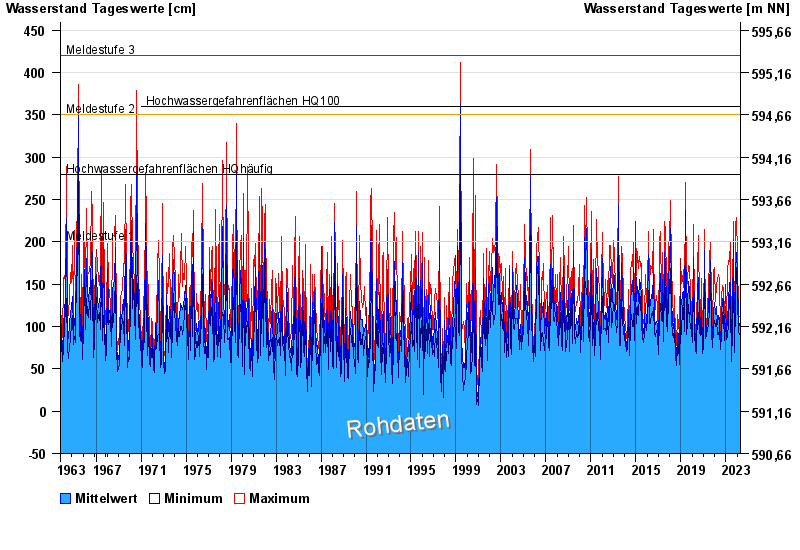
Gesamtzeitraum Türkheim / Wertach
Wasserstand vom 01.11.1963 bis zum 20.04.2024
Hinweis
Beeinflussung durch Kraftwerksbetrieb
- Meldestufe 1 200 cm
- Meldestufe 2 350 cm
- Meldestufe 3 420 cm
- Hochwassergefahrenfläche HQ100 360 cm
- Hochwassergefahrenfläche HQhäufig 280 cm
| Datum | Mittelwert [cm] | Maximum [cm] | Minimum [cm] |
|---|---|---|---|
| 20.04.2024 | 92 | 93 | 91 |
| 19.04.2024 | 90 | 97 | 85 |
| 18.04.2024 | 84 | 94 | 77 |
| 17.04.2024 | 72 | 92 | 60 |
| 16.04.2024 | 69 | 76 | 65 |
| 15.04.2024 | 69 | 79 | 62 |
| 14.04.2024 | 66 | 68 | 65 |
© Bayerisches Landesamt für Umwelt 2024