
- Startseite >
- Flüsse >
- Wasserstand >
- Bayern >
- Dürnhausen >
- Jahresgrafik

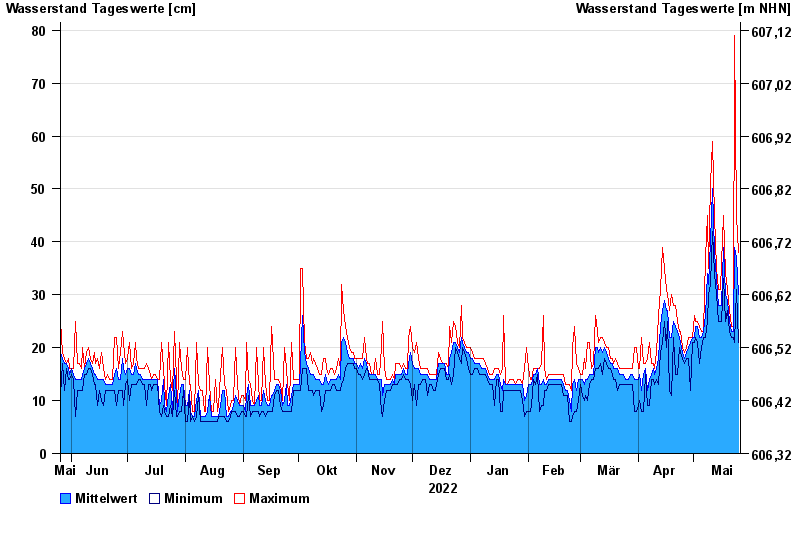
Jahresgrafik Dürnhausen / Lothdorfer Bach
Wasserstand vom 26.05.2022 bis zum 25.05.2023
Hinweis
Messwerte beeinflusst durch Kraftwerkssteuerungen. Abflusswerte zu niedrig nach Profiländerung. Muss angepasst werden
- 06.06.1968 Wasserstand: 149 cm
- 22.05.1999 Wasserstand: 144 cm
- 18.06.1979 Wasserstand: 140 cm
- 10.08.1970 Wasserstand: 121 cm
- 27.06.2009 Wasserstand: 119 cm
| Datum | Mittelwert [cm] | Maximum [cm] | Minimum [cm] |
|---|---|---|---|
| 25.05.2023 | 30 | 38 | 21 |
| 24.05.2023 | 37 | 45 | 31 |
| 23.05.2023 | 39 | 79 | 21 |
| 22.05.2023 | 23 | 24 | 22 |
| 21.05.2023 | 23 | 24 | 22 |
| 20.05.2023 | 25 | 27 | 23 |
| 19.05.2023 | 29 | 31 | 27 |
© Bayerisches Landesamt für Umwelt 2024